Can You Drive to Alaska?
Written by the Zen Godfrey - Alaska.org. Updated March 2026.
Yes, you can drive to Alaska! While flying or taking a cruise are popular options for getting to Alaska, driving offers flexibility, scenic beauty, and can be cheaper for longer trips.
My last trip on the Alaska Highway was in 2017, but ever since my parents moved out of state, they’ve driven it about every other year. It’s their preferred way to get to Alaska. Nobody repeats a drive of this length by choice unless it genuinely delivers, and it does!
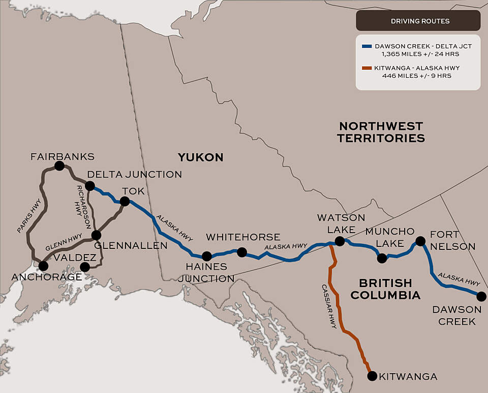
There are two main routes through Canada. The most popular option is the Alaska Highway, which runs 1,387 miles from Dawson Creek, BC to Delta Junction, AK. You can also opt for the more remote Cassiar Highway, a 450-mile route with less traffic and fewer services. Most people take 5 to 7 days for the trip, driving 6 to 8 hours each day.
When Should you Drive to Alaska?
The best time is late May through mid-September. You'll have warmer weather, more daylight, and better road conditions (though, you should always be prepared for construction delays during the short summer repair season). Outside of this window, campgrounds are closed and many of the hotels and lodges close in winter as well.
Main Routes through Canada
When driving from the contiguous United States to Canada, you can choose from over 100 border crossings (there are 13 in Washington alone!). Once in Canada, you'll connect with one of the following routes:
Alaska Highway
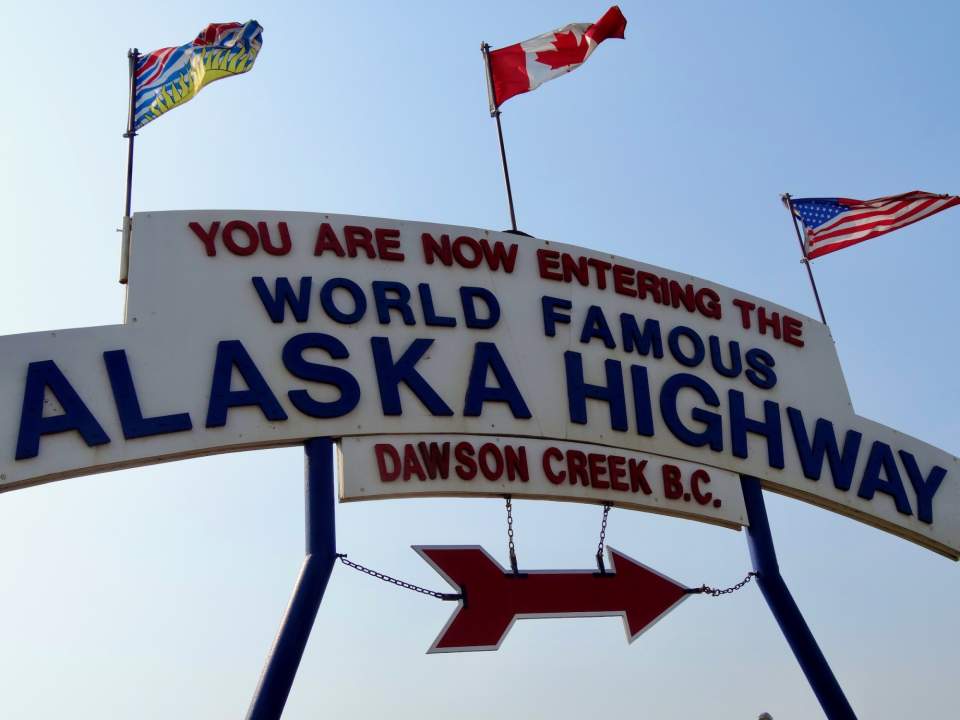
Take your photo by the Alaska Highway sign in Dawson Creek to mark the start of your journey
The more popular option, the 1,387-mile-long Alaska Highway stretches from Dawson Creek, British Columbia, to Delta Junction, Alaska. While this route is the more heavily trafficked of the two, you’ll also find more spots for gas, food, and accommodations. You’ll also pass cool attractions like Liard River Hot Springs and Muncho Lake.
There are many ways to do this drive, but here’s one example of how we’ve done the drive between the Alaska/Canada border crossing in Washington State and Tok, Alaska, taking 6 days:
Day 1
Drive about 5 hours beyond the border and camp in Green Lake, British Columbia. (5-7 hrs, depending on where you started that morning)
Day 2
Drive from Green Lake to Crooked River. (5 hrs)
Day 3
Drive from Crooked River to Fort Nelson. Quesnel is a great place to stop for the grocery store, currency exchange if you haven’t switched to Canadian dollars yet, and the Quesnel Recreation Centre in the middle of town has showers and a swimming pool, which is worth knowing if you’re camping.
If you want to officially start at Mile 0 of the Alaska Highway, take Highway 97 into Dawson Creek and stop at the visitor center. There’s a Surveyor Statue on the roundabout that’s worth the photo opportunity to mark the start of your drive.
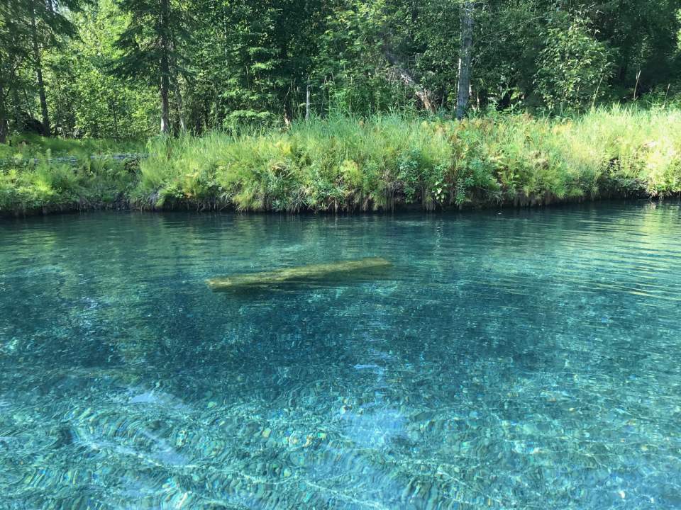
Liard Hot Springs welcomes any weary driver!
Day 4
Fort Nelson to Liard Hot Springs. The drive starts to change character again after Fort Nelson. It begins to feel genuinely northern. You’ll pass through the Northern Rockies Provincial Park, and then the landscape opens. Bison start appearing along the highway; we saw several in the early morning hours on the road between Fort Nelson and Liard. Muncho Lake is a beautiful stop, with pullouts for lunch, several hiking trails nearby, and Dall sheep often visible on the rocky cliffs.
Liard Hot Springs is one of the best stops on the entire drive. Make camping or lodge reservations well in advance if you want to stay the night. If you’re just passing through there's a parking area to reach the springs. After you park you'll follow an elevated boardwalk to reach the springs. There you'll find a beautiful raised platform with changing areas and restrooms. When you're ready to get in, there are steps down into the pool. The hot springs are natural with a rocky bottom, crystal clear water, and multiple pools ranging from warm to very hot. After several days on the road, nothing feels better than floating in these pools. There’s a day use fee per adult, child, or you can purchase a family pass. (4 hrs. We planned a shorter driving day on purpose to give us plenty of time to enjoy the hot springs!)
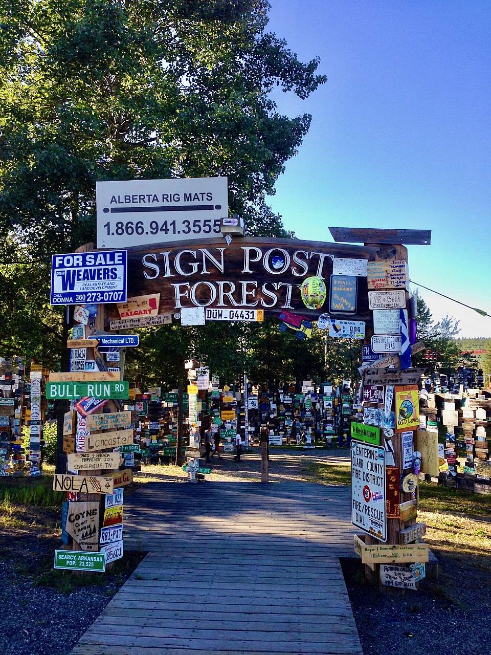
Walk through the Sign Post Forest in Watson Lake, Yukon
Day 5
Liard Hot Springs to Whitehorse, Yukon. Welcome to the Yukon! Walk through the Sign Post Forest in Watson Lake where travelers have been nailing signs from their hometowns to posts since 1942. There are now tens of thousands of them! See if you can find one from somewhere you know. The Yukon feels different from British Columbia in a way that’s hard to explain until you’re there. The air smells sweet like the dense forest forest around you, and there’s a stillness to it that hits you when you stop and pay attention.
Whitehorse is the major city on this route and a good place to spend the night or even take a rest day. Wolf Creek Campground is just before town if you’re camping, and there are hotels and RV parks within the city. Walk along the mighty Yukon River and find the historic S.S. Klondike sternwheeler. (7 hrs)
Day 6
Whitehorse, Yukon to Tok, Alaska. This is a long day, but so beautiful. Haines Junction is a great spot to fuel before the long stretch by Kluane Lake. This long stretch is one of the most striking views on the entire drive. There are pullouts with picnic tables; use them if the wind isn’t too strong, because it can be gusty along the lake. After Kluane Lake and until you reach the Alaska Border, it’s sparse. There’s mountains, boreal forest, and not much else. If you stop, be prepared for bugs (never hurts to have a bug net in your car to cover your face). The Beaver Creek Visitor Information Center, just before the border, is a good final Canadian stop. After the border crossing, it typically takes about 1.5 – 2 hours to reach Tok, Alaska. Once in Alaska, you can decide where you want to go next! (7.5 hrs) Here’s a 10 Day itinerary from Tok, as an example.
Cassiar Highway
The Cassiar Highway (Highway 37) runs about 450 miles (724 kilometers) from the Kitwanga Junction along the Yellowhead Highway to Junction 37 where it meets the Alaska Highway just 13 miles west of Watson Lake, YT.
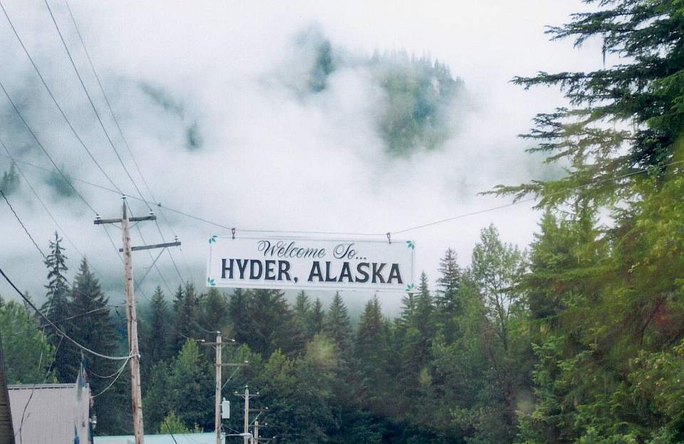
Hyder, Alaska surrounded by the Tongass National Forest
There’s generally less traffic along this route. It’s technically two lanes, but often feels like one and can be tight for larger RVs and trailers. Highlights include Bear Glacier (as a side trip to Stewart, BC and Hyder, AK on 37A), Jade City, and the Spatsizi Plateau Wilderness Provincial Park.
The detour into Stewart, BC and Hyder, AK on Highway 37A is worth the time. This takes you through the Tongass National Forest and past Bear Glacier — lush, green, dramatic country that looks nothing like the rest of the drive. Hyder is one of the smallest communities in Alaska, and crossing the border there is a relaxed experience. The cons of this route is that there are fewer services than the Alaska Highway. Camping is sparser between towns, so plan ahead. Stop for gas when it’s available, and take advantage of local eateries when you see them. But, in our experience, less traffic meant more opportunities to see wildlife. We saw several bears along this route.
The Cassiar can save a few hours of driving time compared to the Alaska Highway. If you’re in a standard vehicle and comfortable with a more remote drive, it’s worth considering.
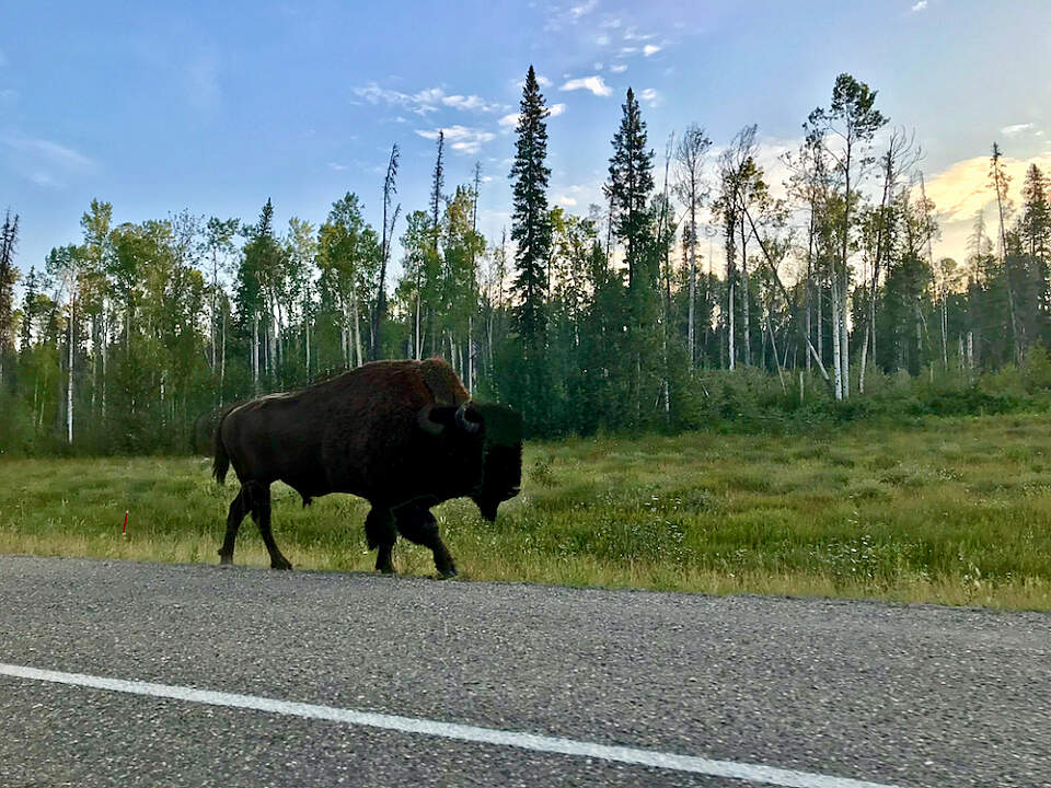
Bison early in the morning near Liard Hot Springs
Services, Road Conditions & Resources
When driving to Alaska, it’s important to plan your journey. On both the Alaska Highway and Cassiar Highway, you’ll find hotels, motels, campgrounds, gas stations, and grocery stores, but they can be quite spread out. It's advisable to carry extra supplies, including food, water, and emergency essentials.
Here are some great resources:
- The Milepost includes details on places to stop, so you can plan in advance.
- 511 Yukon and DriveBC are great resources for real-time road conditions.
- Facebook groups is where travelers share stories from recent trips and ask questions about upcoming drives.
- Our Alaska Map will direct you to the best things to see and do once you arrive in the 49th state. And check out this 10-day loop from Tok, which could easily be combined with a 5-day or 7-day trip throughout the Kenai Peninsula.
- If you're looking to rent a vehicle to drive to Alaska, contact GoNorth Car & RV Rental. They have offices in Whitehorse, YT and Seattle, WA.
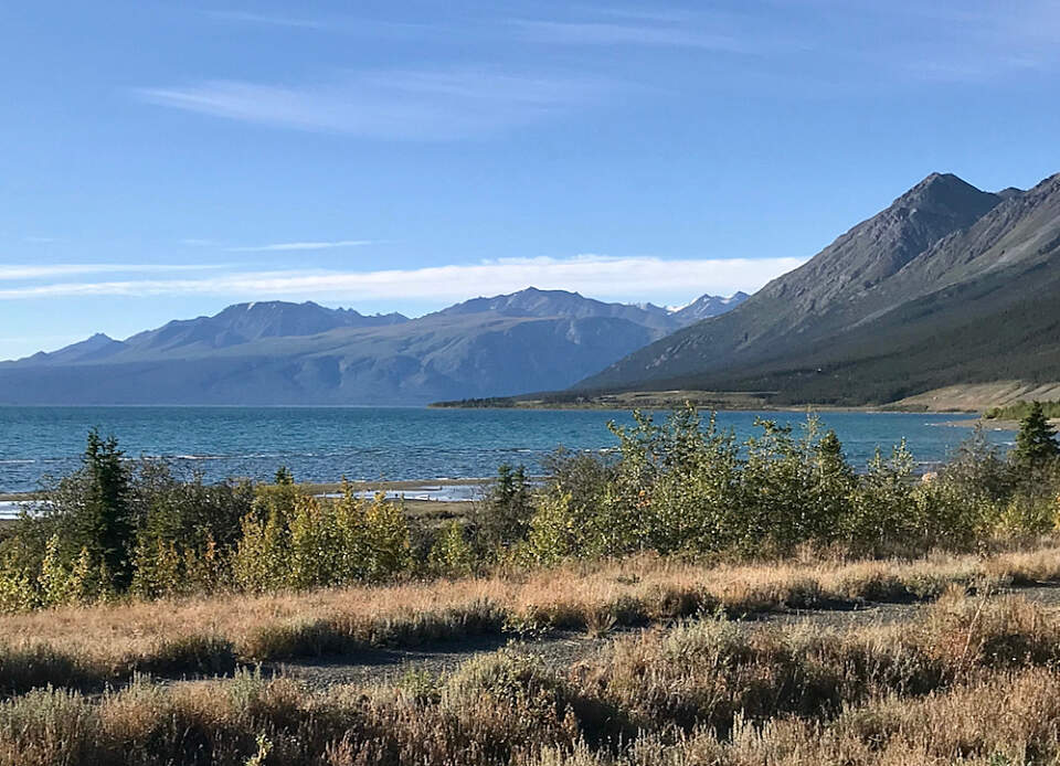
Kluane Lake, YT
How Long Does it Take to Drive to Alaska?
From one of the U.S.-Canada border crossings in Washington State, most people take 5 to 7 days to reach Alaska, driving 6 to 8 hours per day. Your pace, of course, may vary. You could easily spread the drive out over 10 to 14 days and enjoy the hiking and hot springs along the way.
Why Drive to Alaska Instead of Fly?
Driving to Alaska offers a unique and immersive experience that flying or taking a ferry/cruise might not provide. Here are a few reasons why you might consider driving:
- Flexibility and freedom. Driving allows you to set your own pace and explore less-visited areas.
- Scenic beauty. Both the Alaska Highway and Cassiar Highway offer breathtaking scenery and the opportunity to see wildlife. It's not uncommon to see black and brown bears, bison, fox, and more. And, You can’t get to Hyder, the Cassiar wilderness, or Liard Hot Springs any other way.
- Cost savings. Driving to Alaska can be a more cost-effective option for a longer trip by lowering your accommodation costs if you camp or stay in budget-friendly motels.
- Alaska & Canada's Vastness. The drive gives you a physical understanding of Alaska’s remoteness that no flight can. When you’ve spent six days covering terrain to get to Alaska, you understand why things work differently here.
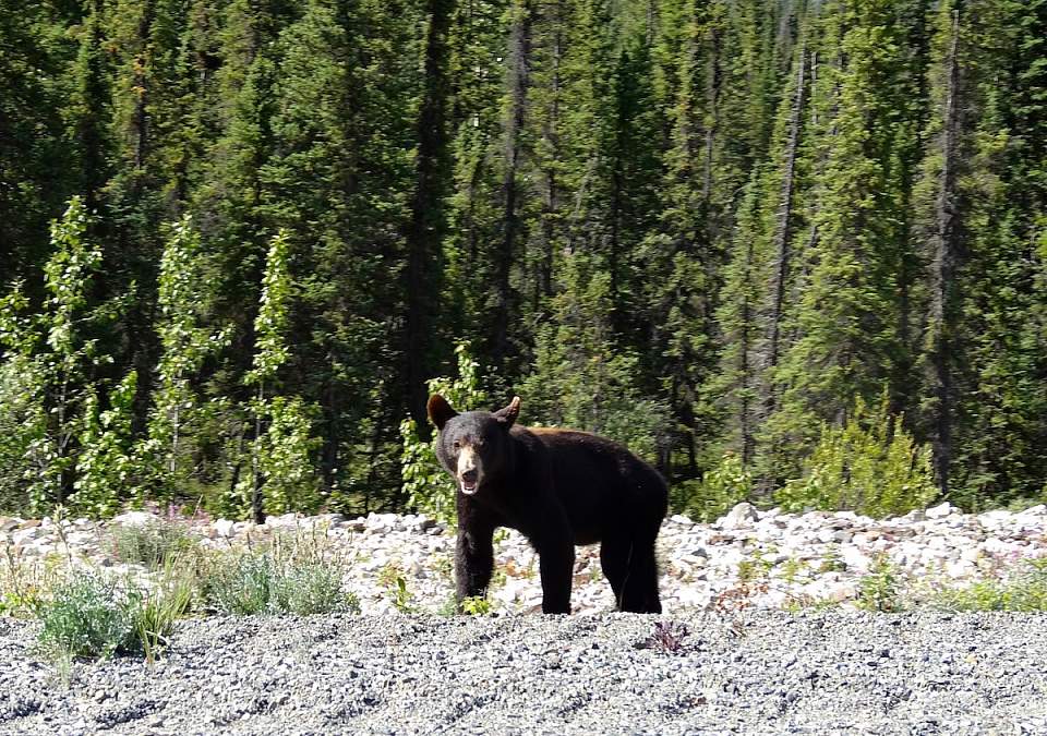
A curious black bear watches us drive by on the Alaska Highway
Other Tips
- Make sure you have the right identification.
- If you're traveling with animals, you'll need paperwork for them too.
- Carry extra supplies, including food, water, and emergency gear.
- Fill up on gas when you see stations, especially on the Cassiar route.
Frequently Asked Questions
- Do I need a passport to drive to Alaska? Yes, you need a valid passport or other approved identification to cross the Canadian border. Check the Canadian Border Services Agency website for current requirements.
- Can I drive to Alaska in winter? Technically, yes, but it’s a tougher, trickier journey. Most campgrounds, hotels, and services are closed, roads can be snowy and icy, and you’ll have very limited daylight hours.
- How much does it cost to drive to Alaska? Costs can vary widely depending where you stay, how you eat, and how many miles per gallon your car gets. Budget for gas (the routes are long), accommodations (camping is cheapest, motels are moderate), food, and extra supplies. Many people find it more economical than flying if they’re bringing a family and camping along the way.
- Is the Alaska Highway paved? Yes, but come prepared for some rough and gravel patches in sections under construction. The Cassiar Highway is also paved but has more unpaved sections and rougher conditions.
Explore Further